An enormous “derecho” storm cluster with winds up to 100mph has taken shape in the midwestern US, leaving a trail of destruction in its wake and heading straight for Chicago – as if the Windy City doesn’t have enough problems.
The devastating storm – given the rare classification of “Particularly Dangerous Situation” by government meteorologists – is expected to pummel northern Illinois and southern Wisconsin with winds of up to 100mph (160kph) through 7pm local time, according to the US Storm Prediction Center.
The likelihood of a Derecho impacting IA, IL, IN, and WI this afternoon has prompted an upgrade to a Moderate Risk of severe weather and the issuance of a "Particularly Dangerous Situation" Severe Thunderstorm Watch. Widespread severe wind gusts of up to 80-100 mph are possible. pic.twitter.com/Bl5GP8fg0u
Potentially causing more damage than a tornado, a derecho is defined as a “line” of thunderstorms stretching at least 250 miles (402km) with wind gusts above 58mph including multiple separated gusts of over 75mph. Damage caused by such formations is termed “straight-line wind damage” to differentiate it from that caused by tornadoes.
Monday’s derecho, which took the shape of a dragon in some ominous radar images, may also be accompanied by large hail and even a few tornadoes, according to the SPC.
NEW VIDEO: This power pole was no match for the strong winds in today's #derecho.
Insane footage from the derecho moving through eastern Iowa this morning. This is from Belle Plaine, Iowa which is east of Des Moines but west of Cedar Rapids. #IAwxpic.twitter.com/nKdfonpveC
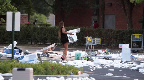
The storm arrives as Chicago is still reeling from a night of protests sparked by a police shooting that quickly degenerated into massive looting. Chicago police have pledged to step up their presence in the downtown area, with Mayor Lori Lightfoot warning access to the business district will be restricted “until we know that our neighborhoods are safe.”